ISRO Successfully Launches NISAR Satellite in Collaboration with NASA from Sriharikota Andhra Pradesh
When two of the world’s top space agencies come together, the result is bound to be out of this world—literally.
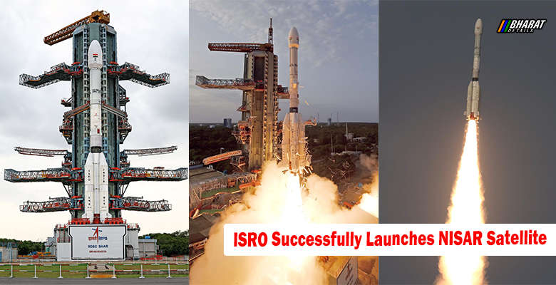
📡 ISRO Successfully Launches NISAR Satellite — a groundbreaking moment not just for India, but for the entire planet.
The Indian Space Research Organisation (ISRO), in collaboration with NASA, successfully launched the world’s most advanced and expensive Earth observation satellite—NISAR (NASA-ISRO Synthetic Aperture Radar Satellite)—from Sriharikota, Andhra Pradesh. The moment the GSLV-F16 rocket roared into the sky at 5:40 PM on Wednesday, carrying this $1.3 billion marvel, history was made.
“Liftoff. And we have liftoff! GSLV-F16 has successfully launched with NISAR onboard,” announced ISRO via their official X handle.
This is not just another satellite launch. It’s the first-of-its-kind joint mission between India and the United States, and the first time a GSLV vehicle has been used to inject a satellite into a Sun Synchronous Polar Orbit—a feat typically accomplished using PSLV rockets.
Contents
From Aryabhata to NISAR: A Giant Leap
ISRO Chairman Dr. V Narayanan reflected on this milestone with pride.
“From the humble beginning with Aryabhata in 1975, where we relied on other countries, to launching NISAR with NASA—we’ve come a long way,” he told media post-launch.
Weighing 2,392 kg, NISAR will orbit Earth once every 97 minutes and revisit the same location every 12 days, capturing highly detailed images of Earth’s surface and oceans. Its mission life? A solid five years, during which it’s expected to be a game-changer in disaster preparedness and climate change monitoring.
What Makes NISAR So Special?
Unlike conventional satellites, NISAR carries dual-band radar technology:
- L-band radar developed by NASA
- S-band radar built by ISRO
This dual radar system allows it to detect minute surface movements, land shifts, ice sheet melting, deforestation, and even infrastructure development. According to NASA, NISAR is “the most sophisticated radar we’ve ever built.”
🛰️ The satellite will be able to detect land deformation as small as a few centimeters, which could help predict earthquakes, landslides, and volcanic activity. It will also aid in monitoring glacial melting in Greenland and Antarctica and track urban sprawl and deforestation with pinpoint accuracy.
A Satellite That Serves the Globe
In the words of NASA’s Earth Science Director Karen St Germain, who attended the launch event in India:
“With NISAR, we’ll see precursors to natural hazards… we’ll track climate change, and spot even human-driven changes from farming and buildings. This satellite will truly serve the entire world.”
The repeated scans every 12 days will generate a massive volume of Earth observation data—vital for researchers, governments, and climate scientists around the globe.
Why This Matters for India and the World
India is not just a launchpad here—it’s a tech partner, scientific contributor, and global leader in satellite technology.
This success showcases India’s growing capability and credibility in the global space community. It reinforces the nation’s commitment to disaster preparedness, climate resilience, and technological leadership.
If you’re interested in how India is also working to protect digital citizens, you might want to explore how the government is cracking down on offensive content platforms…
✨ You’ll definitely want to check this out too:
👉 OTT App Banned in India: Full List of 25 Platforms Blocked by Government Over Vulgar Content
The Road Ahead
As NISAR settles into its orbit, its real journey begins—observing Earth like never before, helping prevent disasters before they strike, and contributing data that could shape climate policies worldwide.
From rural farmlands in Bihar to glaciers in Antarctica, NISAR will be watching over Earth—silently, precisely, and tirelessly.
India and the world now have a new eye in the sky. One that promises to change how we see—and protect—our only home.